About a year ago, I narrowed the focus of my model railroad plan to the segment of the P&LE main line between McKeesport and McKees Rocks, where I would model the through service of the Baltimore & Ohio Railroad’s named trains, which used the P&LE line, with a possible cameo appearance by the Pennsylvania Railroad line that parallels part of the P&LE in Pittsburgh. Over the past year, I’ve continued learning more historical information about these railroads, which has helped me begin to plan which trains and industries I’ll model, and which locomotive and car models I can purchase that would be suitable for the layout. I also began to practice some basic track planning skills in Adobe Illustrator, to help me visualize how much space is needed for things like loops, yards and stations, which has has prompted me to prepare for the possibility of eliminating scenes from the plan if the space requirements are too high.
Elimination of McKees Rocks & Esplen
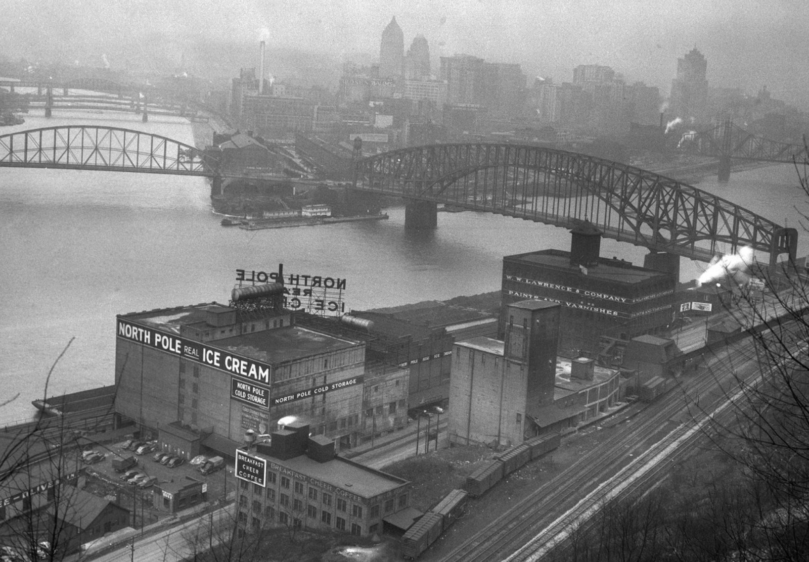
I cut the westernmost scene, McKees Rocks, because it’s the site of the locomotive service facility, fabrication shops and a classification yard, which would take up a huge amount of flat, open space, and I’m much more interested in using the limited space to model passenger operations and city streets. With McKees Rocks relegated to the “beyond-the-layout” realm in hidden staging, Esplen would be the westernmost scene. It was a long scene that didn’t have much to model except some industries on its easternmost end, including two iconic, rail-served buildings: North Pole Ice Cream and W.W. Lawrence & Co. Paints & Varnishes. So, Esplen got the chop, and that cluster of industries is a new scene named “West End”, bordered roughly on the west by the West End Bridge, and on the east by the Point Bridge, as pictured below.
Duquesne is now Riverton
The Duquesne scene was initially named that because, even though the city of Duquesne and the US Steel Duquesne Works were in the background, across the river from this scene, it was the only part of the scene I could name at the time. The P&LE line in this scene is located in North Versailles Township, but the tracks, including a yard, are separated from the rest of North Versailles, situated at the bottom of a cliff, squeezed up against the Monongahela River. I’ve since learned that this area actually contained two yards: B&O’s Demmler Yard and P&LE’s Riverton Yard. Thus, the scene of Duquesne has been renamed “Riverton”. Even if I only end up modeling the P&LE yard, it may be a good place to model interchange with the B&O.
Space Requirement Reality Check
Being somewhat unimpressed by RailModeller Pro track planning software, I decided to try using Adobe Illustrator for track planning, not to begin an actual track plan, but to see how well it would work (or not). Being experienced with Illustrator, it didn’t take long to confirm that I would have more flexibility and less of a learning curve using it instead of RailModeller Pro, but in the course of doing this, I realized that my sense of the space required for everything I want to model is pretty far off from reality. Placing 28-32″ radius half-circles onto a 15×15′ artboard, along with shapes representing the length of a 7-car passenger train, was eye-opening. One of my first thoughts was that the scenes of West End and Terminal are absolutely required, and the challenge will be to see how far east I can go from there. I also thought this could be another way out of depicting steel mills in six locations, by just eliminating some in-between scenes.
Sticking to What I Like
The potential elimination of more than one steel mill scene, along with the fact that selective compression also might not allow inclusion of the P&LE’s Point Bridge Yard in the Terminal scene, is a little disappointing from an operations perspective. But my main interest is modeling the B&O through trains, and also, more recently, P&LE commuter trains. With the coach yard and turn table located in the Terminal scene, the operations I’m most interested in are still there. Update from October 2021: While reading the new book Pittsburgh & Lake Erie in Allegheny County Vol. 1 (Depot Square Publishing) earlier this year, I learned that the turntable at the terminal was no longer in use in my time period of the late 1940s, and steam engines were then turned at McKees Rocks, which meant a lot of steam engines facing either direction were running light, in reverse, for the four miles or so between the terminal and McKees Rocks. I can reproduce that operation on my layout, having the locomotives turned on the return loop in West Staging.