
Back in October 2019, I decided that the prototype railroad depicted in my next layout will be the B&O from 1938-1948 in southwestern PA somewhere between Meyersdale and New Castle, likely including Pittsburgh. After four months of research and consideration, I’ve narrowed my focus to the Pittsburgh & Lake Erie line from McKeesport to McKees Rocks, a segment that partially spans two divisions over a distance of about 15 miles.
I decided pretty quickly to make my southernmost potential station Connellsville, instead of smaller Meyersdale, since it was a pretty significant station, junction and yard, making a logical end point for operations. Although I don’t know how much space will be available for the layout, the approximately 100 miles between these two points seemed like a lot, so I thought the best planning approach would be to research and document the points of interest that existed along that stretch, and use that information to help me select a shorter segment to model.
My research and documentation started by following the present-day CSX main line from New Castle to Connellsville via Google Maps satellite view, which revealed many former railroad facilities, such as turntables, tunnels, bridges and stations, plus evidence of former industries, such as a distillery and a coal-fired power plant. Each time I came upon something that looked interesting, I added it to a spreadsheet, making note of the location and other information I found about it on the Internet. The list currently has 74 points of interest, including 25 bridges, 4 tunnels, 9 yards and 6 steel mills. I later categorized the points by type (station, industry, bridge, etc.) and numbered them sequentially so that I can sort by type but also return the list to its actual north-south sequence. I continue to add points of interest to the list.
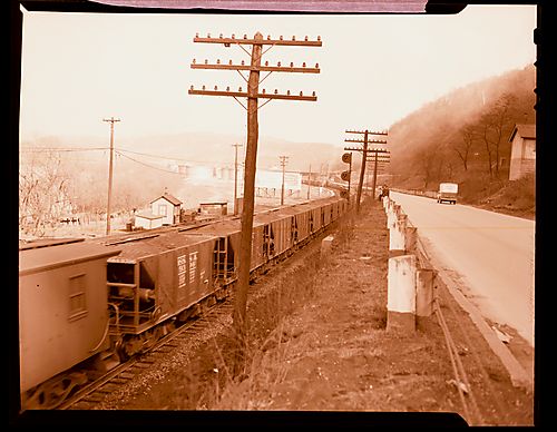
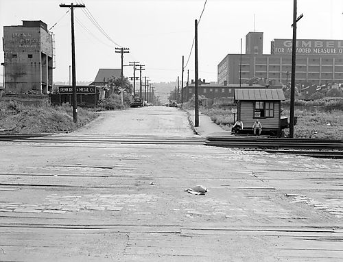
My research got a huge boost when I came across the website historicpittsburgh.org. Hosted by the University of Pittsburgh Library System, this huge collection of high-res historic photos of the Pittsburgh region has a collection of over 2,000 photos of the P&LE Railroad from 1886 to 1971. Jackpot! When I realized how much useful modeling information was available in these photos, I began downloading copies of select images to add to an album on my Mac, just in case they’re no longer available online some day, and so that I have quicker access to pertinent images. After collecting all of the relevant P&LE photos, I began collecting other useful images of storefronts, street scenes and billboards from 1938-1948, to help guide my modeling.
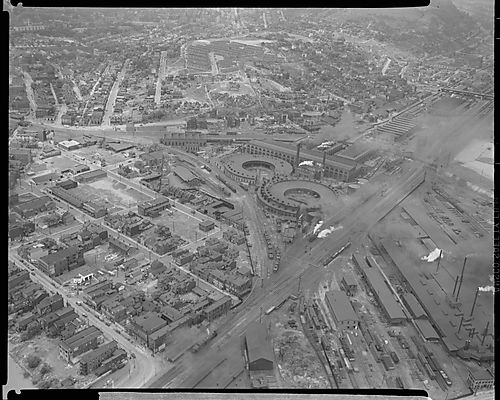
Another good source of information has been the website historicaerials.com. Although the image quality usually isn’t very good on aerial shots from the 1940s, it’s still been very helpful to see historic aerial images. It’s like using Google Maps satellite view, except it lets you go back in time and figure out when industries and railroad facilities of the past were built or torn down.
After seeing so many good quality historic photos of the P&LE in the Pittsburgh region, I decided I could easily make an interesting model railroad that stretches only from McKeesport to McKees Rocks, a distance of about 15 miles. Right now, 41 of the 74 points of interest on my spreadsheet are located between these two cities. I feel pretty confident right now that these will be the starting and ending points I stick with (plus staging that may represent New Castle or Connellsville), and if I ever have opportunity to expand the layout, I’ll still have my list of interesting places in the northern and southern ends that have now been eliminated from consideration.
After narrowing it down to this segment, I began an effort to compartmentalize the route into scenes, which currently consists of the following:
- McKees Rocks
- Esplen
- Terminal
- South Side/Carson Street
- J&L South Side Works
- Hays
- Homestead
- Rankin
- Braddock
- Duquesne
- McKeesport
One big question I’ve been thinking about lately is how to orientate the scenes so that they can all be viewed from the river shore, which is tricky because the main line switches sides of the river between Homestead and Rankin. I only want to model the river shore, on the front edge of the viewing areas, so that I don’t have to model all of the many elaborate bridges that cross the Monongahela River. Modeling just the bridge approaches that cross above the tracks would be much easier. More on that as I come up with more ideas.