Tube Works Map

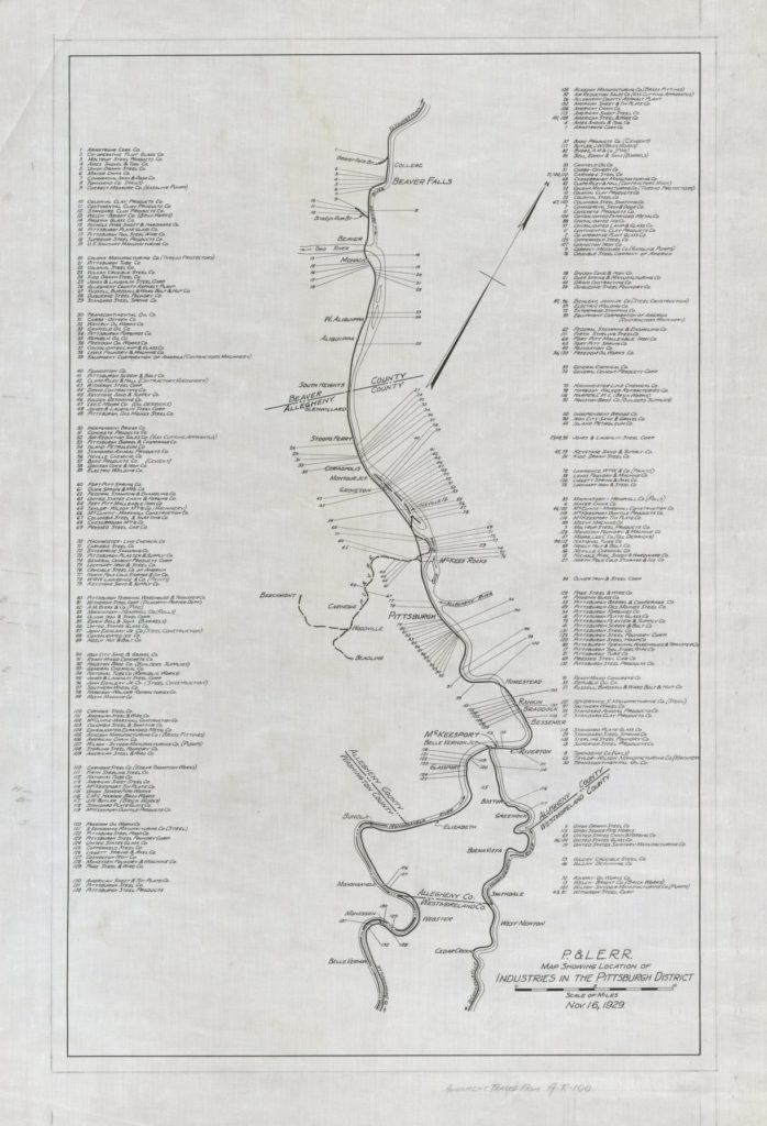
I had a great stroke of luck this week while searching through P&LE company records on Historic Pittsburgh. After finding a map of all industries on the line and a technical drawing of the station building and platforms, I came across this undated map of the U.S. Steel National Tube Works plant in McKeesport. It was a huge place, and would have to be selectively compressed a lot for a medium-size model railroad, whether modeled in three dimensions or just as a backdrop.

Update from April 2022: Even without knowing what size constraints I’ll be working with when building this layout, I don’t think there could possibly be enough space to include the National Tube Works in any way other than something depicted on a backdrop, maybe with some building flats, smoke stacks and a siding and/or spur for freight operations. As with the rest of the layout, the focus of the McKeesport scene is the B&O passenger trains, which are in the foreground from the layout viewer’s perspective, with the P&LE main and tube works a few blocks back, but still dominating the sky. I’ve recently read about the “Bessemer blow” that would light up the night sky …

Continue Reading →

P&LE Terminal Drawing

Another good find on the Historic Pittsburgh site is this technical drawing of the Pittsburgh terminal, showing the layout of the station building and platforms. I was glad to find this, because even though I’ve already collected several historic photos of the terminal, I wasn’t yet sure how many tracks there were in the station. Apparently there were a total of 13, which is more than I expected. This plan is undated, but it’s probably still good enough to use as a planning reference. I’d like to some day model this building, and this floor plan should be helpful in that regard as well.

Continue Reading →

P&LE Industries Map

Another great find on the Historic Pittsburgh site is this map titled Industries in the Pittsburgh District, published by the P&LE, showing the names and locations of industries along the line. It’s from late 1929, but I think it’s still probably a good reference for my purposes. At the very least, it tells me what on-line industries I can model, and researching the company names may also lead me to additional pertinent information.

Continue Reading →

February Progress

Sat Feb 1: Began BN SD9 DCC conversion.
Sun Feb 2: Continued SD9 conversion. Decoder was interfering with gears.
Sun Feb 9: On Building 2, painted contrasting brick colors on two sides, plus all window sills and window headers.

Sun Feb 16: Continued SD9 conversion. To make more room for the decoder and speaker, I removed weights that had been installed in the top of the shell. During testing, I noticed that the tiny incandescent lights in the front and rear were getting way too hot. The resistors I chose were based on getting a light intensity that looked about right, but I never tested for heat. Upon discovering this, I decided to replace them with LEDs so that (hopefully) I won’t have to tear this apart to replace bulbs in the future.

Sat Feb 22: UNW Train Show in Monroe. Picked up some 3/32″ heat-shrink tubing for the SD9 conversion, a used book titled “Guide to North American Steam Locomotives” (which includes railroad-by-railroad histories and rosters, which should be a great resource for planning what equipment to use), an old Athearn blue box B&O hopper car kit, an Accurail P&LE hopper kit, a P&LE/NYC caboose (which turns …

Continue Reading →

15-Mile Segment Selected

Back in October 2019, I decided that the prototype railroad depicted in my next layout will be the B&O from 1938-1948 in southwestern PA somewhere between Meyersdale and New Castle, likely including Pittsburgh. After four months of research and consideration, I’ve narrowed my focus to the Pittsburgh & Lake Erie line from McKeesport to McKees Rocks, a segment that partially spans two divisions over a distance of about 15 miles.

I decided pretty quickly to make my southernmost potential station Connellsville, instead of smaller Meyersdale, since it was a pretty significant station, junction and yard, making a logical end point for operations. Although I don’t know how much space will be available for the layout, the approximately 100 miles between these two points seemed like a lot, so I thought the best planning approach would be to research and document the points of interest that existed along that stretch, and use that information to help me select a shorter segment to model.

My research and documentation started by following the present-day CSX main line from New Castle to Connellsville via Google Maps satellite view, which revealed many former railroad facilities, such as turntables, tunnels, bridges and stations, plus evidence …

Continue Reading →